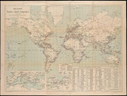
Weltkarte der Funken- u. Kabel-Telegraphie.
- Published/Created:
- Berlin :
Gea Verlag G.m.b.H.,
[1911?] - Copyright Date:
- [1911?]
- Physical Description:
- 1 map : color ; 52 x 87 cm
- Notes:
- Includes two inset maps: Mittelländisches Meer (1:18,000,000) and Nordsee und Kanal (1:10,800,000).
- Associated Names:
- Gea verlag [Cartographer]
Berliner Lithographisches Institut [Lithographer] - Topics:
- Cables, Submarine--Maps.
Telegraph--Maps. - Language:
- German
- Scale:
- Scale 1:47,000,000
- Coordinates:
- a
47000000
-180.000000
180.000000
090.000000
-090.000000
(W 180°--E 180°/N 90°--S 90°). - Genre:
- World maps
- Format:
- Map
- Content Type:
- Maps, Atlases & Globes
- Rights:
- The use of this image may be subject to the copyright law of the United States (Title 17, United States Code) or to site license or other rights management terms and conditions. The person using the image is liable for any infringement.
- Access Restrictions:
- Public
- Call Number:
- BrSides Double Folio 2018 94
- Orbis Record:
- 13881266
- Yale Collection:
- Beinecke Library
- Digital Collection:
- General Collection, BRBL, Yale University
- oid pointer:
- 16669387
- Extent of digitization:
- Complete work digitized.
- OID:
- 16664844
- PID:
- digcoll:4627866