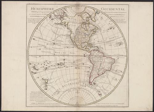
Hemisphere occidental : dressé pour l'usage particulier du Roy, sur les observations astronomiques et géographiques, qui se trouvent rapportées dans l'histoire et dans les mémoires de l'Académie Rle. des Sciences / par Guillaume de l'Isle, premier ge
- Creator:
- L'Isle, Guillaume de, 1675-1726
- Published/Created:
- Paris :
Dezauche,
[1782] - Physical Description:
- 1 map : hand col., mounted on linen ; 49 cm. diam., on sheet 54 x 75 cm.
- Notes:
- In lower right: Ph. Buache, P.G.d.R, d l'A.R.d.S. Gendre de l'auteur. Avec privilège du Roi.
Library's copy stamped on backing: Yale University Library, Karpinski-Von Wieser Map Collection.
Relief shown pictorially. - Topics:
- America--Discovery and exploration--Maps
Western Hemisphere--Maps - Topics:
- Karpinski-von Wieser Map Collection--Stamp
- Topics:
- Buache, Philippe, 1700-1773
Cook, James--(1728-1779)--Travel--Maps
Dezauche, J - Language:
- French
- Scale:
- Scale [ca. 1:52,000,000].
- Coordinates:
- 52000000
a - Genre:
- Maps
- Format:
- Map
- Content Type:
- Maps, Atlases & Globes
- Rights:
- The use of this image may be subject to the copyright law of the United States (Title 17, United States Code) or to site license or other rights management terms and conditions. The person using the image is liable for any infringement
- Access Restrictions:
- Public
- Call Number:
- 70 1782
- Folder:
- BRBL_00356
- Orbis Record:
- 6123055
- Yale Collection:
- Beinecke Library
Sterling Memorial Library - Digital Collection:
- General Collection, BRBL, Yale University
- oid pointer:
- 15534499
- Citation:
- Tooley, R.V. Mapping of America, 26, p. 18
- Extent of digitization:
- Complete work digitized.
- OID:
- 15534027
- PID:
- digcoll:4382892