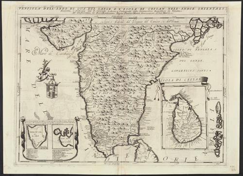
Peninsola dell'Indo di qua del Gange, e l'isola di Ceilan nell'Indie orientali / descritta e dedicata dal P. Coronelli, lettora e cosmografo della serenissima Republica de Venetia all'illustrissimo, et eccellentissimo signor Ottavio Manin, procuratore di
- Creator:
- Coronelli, Vincenzo, 1650-1718
- Published/Created:
- [Venice? :
s.n.,
1696] - Physical Description:
- 1 map ; 42 x 59 cm.
- Notes:
- Includes inset of "Isoletta del Sole" and Trincomalee region, Sri Lanka, and inset of "Isola di Ceilan."
Includes text on verso.
Relief shown pictorially.
Signature mark: Mm. - Topics:
- India--Maps--Early works to 1800
Sri Lanka--Maps--Early works to 1800 - Language:
- Italian
- Scale:
- Scale [ca. 1:4,630,000].
- Coordinates:
- 4630000
a - Genre:
- Maps
- Format:
- Map
- Content Type:
- Maps, Atlases & Globes
- Rights:
- The use of this image may be subject to the copyright law of the United States (Title 17, United States Code) or to site license or other rights management terms and conditions. The person using the image is liable for any infringement
- Access Restrictions:
- Public
- Call Number:
- 59 1696
- Folder:
- BRBL_00315
- Orbis Record:
- 7018267
- Yale Collection:
- Beinecke Library
- Digital Collection:
- General Collection, BRBL, Yale University
- oid pointer:
- 15514693
- Citation:
- Gole, S. Early maps of India, 23b
- Extent of digitization:
- Complete work digitized.
- OID:
- 15511954
- PID:
- digcoll:4378579