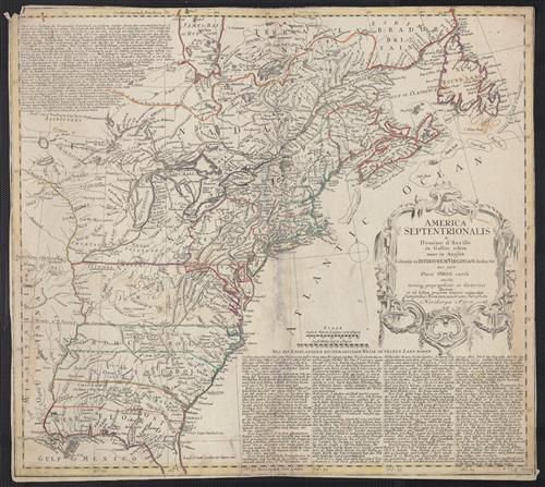
America Septentrionalis a Domino d'Anville in Galliis edita nunc in Anglia : coloniis in interiorem Virginiam deductis nec non Fluvii Ohio cursu aucta notisque geographicis et historicis illustrata et ad bellum praesentis temporis accomodata / sumptibus Homannianorum Heredum.
- Published/Created:
- Noribergae :
[s.n.],
1777 - Physical Description:
- 1 map : hand col. ; 45.4 x 50.5 cm.
- Notes:
- Appears in various eds. of Atlas geographicus maior.
Includes German text relating to English and French territorial claims.
Place names and descriptive notes in English.
Prime meridian: Ferro and London.
Relief shown pictorially. - Associated Names:
- Homann Erben (Firm) [cartographer.]
- Topics:
- North America--Maps--Early works to 1800.
United States--History--French and Indian War, 1755-1763--Maps--Early works to 1800. - Topics:
- Anville, Jean Baptiste Bourguignon d', 1697-1782.
Homann Erben (Firm). Atlas geographicus maior. - Language:
- English
German
Latin - Scale:
- Scale [ca. 1:6,200,000] (W 92°30ʹ--W 51°00ʹ/N 52°30ʹ--N 28°30ʹ).
- Coordinates:
- a
6200000
-092.500000
-051.000000
052.500000
028.500000 - Genre:
- Maps.
- Format:
- Map
- Content Type:
- Maps, Atlases & Globes
- Rights:
- The use of this image may be subject to the copyright law of the United States (Title 17, United States Code) or to site license or other rights management terms and conditions. The person using the image is liable for any infringement
- Access Restrictions:
- Public
- Call Number:
- 755 1777B
- Folder:
- BRBL_00431
- Orbis Record:
- 8350776
- Yale Collection:
- Beinecke Library
- Digital Collection:
- General Collection, BRBL, Yale University
- oid pointer:
- 15636990
- Citation:
- LC Maps of North America, 1750-1789, 69
McCorkle, B.B. New England in early printed maps 1513-1800, 777.2 - Extent of digitization:
- Complete work digitized.
- OID:
- 15604258
- PID:
- digcoll:4377251