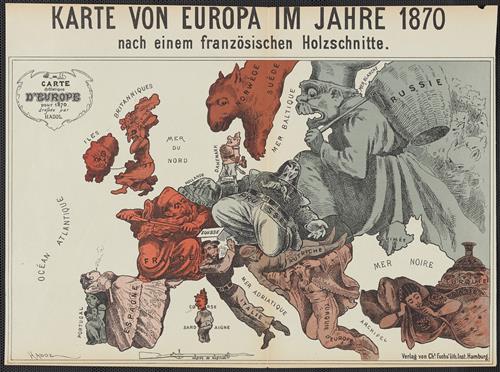
Karte von Europa im Jahre 1870 nach einem französischen Holzschnitte / dressée par Hadol.
- Creator:
- Hadol, Paul, 1835-1875
- Published/Created:
- Hamburg :
Chs. Fuchs' lith. Inst.,
[1870] - Physical Description:
- 1 map :
25 x 39 cm.
col. ; - Notes:
- Caricature map.
Includes text.
National political attitudes are represented by caricatures. - Variant Titles:
- Carte drôlatique d'Europe pour 1870
- Topics:
- Franco-Prussian War, 1870-1871--Maps
- Topics:
- Europe--Maps
Europe--Politics and government--Maps - Language:
- German
- Scale:
- Scale not given.
- Coordinates:
- a
- Genre:
- Caricatures
Maps - Format:
- Map
- Content Type:
- Maps, Atlases & Globes
- Rights:
- The use of this image may be subject to the copyright law of the United States (Title 17, United States Code) or to site license or other rights management terms and conditions. The person using the image is liable for any infringement
- Access Restrictions:
- Public
- Call Number:
- 30 1870C
- Folder:
- BRBL_00032
- Orbis Record:
- 6524842
- Yale Collection:
- Beinecke Library
- Digital Collection:
- General Collection, BRBL, Yale University
- oid pointer:
- 15258907
- Extent of digitization:
- Complete work digitized.
- OID:
- 15258886
- PID:
- digcoll:4361644