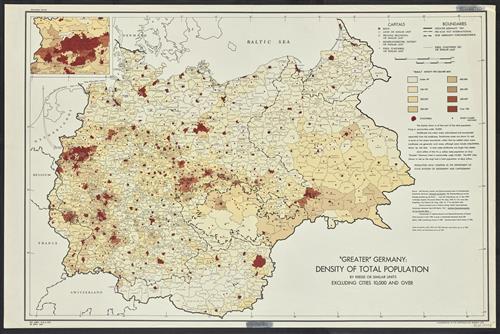
"Greater" Germany, density of total population by Kreise or similar units excluding cities 10,000 and over.
- Creator:
- United States. Office of Strategic Services. Research and Analysis Branch
- Edition:
- Provisional ed.
- Published/Created:
- [Washington, D.C.] :
R & A, OSS,
1945 - Physical Description:
- 1 map : col. ; 60 x 90 cm.
- Notes:
- "No. 6381-R & A, OSS, 28 April 1945."
"Population data compiled in the Department of State, Division of Geography and Cartography."
Inset: [Düsseldorf-Münster area]. - Topics:
- Europe, Central--Population--Maps
Germany--Population--Maps - Language:
- English
- Scale:
- Scale [ca. 1:1,800,000].
- Coordinates:
- 1800000
a
E0060000
E0240000
N0460000
N0560000 - Genre:
- Maps
- Format:
- Map
- Content Type:
- Maps, Atlases & Globes
- Rights:
- The use of this image may be subject to the copyright law of the United States (Title 17, United States Code) or to site license or other rights management terms and conditions. The person using the image is liable for any infringement
- Access Restrictions:
- Public
- Call Number:
- 36eb 1945B
- Folder:
- BRBL_00127
- Orbis Record:
- 6124466
- Yale Collection:
- Beinecke Library
- Digital Collection:
- General Collection, BRBL, Yale University
- oid pointer:
- 15480103
- Extent of digitization:
- Complete work digitized.
- OID:
- 15479625
- PID:
- digcoll:4094223