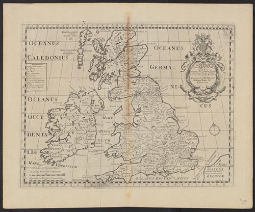
A new map of the Brittish Isles : shewing their antient people, cities and towns of note, in the time of the Romans.
- Published/Created:
- [Oxford] :
[Edward Wells],
[1701] - Copyright Date:
- [1701]
- Physical Description:
- 1 map ; 37 x 49 cm
- Notes:
- "Sutton Nicholls sculp."
Appears in Edward Wells's New sett of maps both of antient and present geography (1701).
Imprint derived from the atlas in which the map was issued.
Kingdoms with boundaries, settlements with Latin names and rivers.
London meridia - Variant Titles:
- New map of the British Isles, showing their ancient people, cities and towns of note in the time of the Romans
- Associated Names:
- Wells, Edward, 1667-1727 [Cartographer]
Nicholls, Sutton [Engraver] - Topics:
- British Isles--Maps
Europe--British Isles - Language:
- English
Latin - Scale:
- Scale approximately 1:2,800,000
- Coordinates:
- a
2800000
-012.000000
002.500000
058.750000
050.000000
(W 12°00ʹ00ʺ--E 2°30ʹ00ʺ/N 58°45ʹ00ʺ--N 50°00ʹ00ʺ). - Genre:
- Maps
- Format:
- Map
- Content Type:
- Maps, Atlases & Globes
- Rights:
- The use of this image may be subject to the copyright law of the United States (Title 17, United States Code) or to site license or other rights management terms and conditions. The person using the image is liable for any infringement
- Access Restrictions:
- Public
- Source Title:
- New sett of maps both of antient and present geography ...
- Call Number:
- 3190 No. 2
- Folder:
- BRBL_00041
- Orbis Record:
- 8197977
- Yale Collection:
- Beinecke Library
Sterling Memorial Library - Digital Collection:
- General Collection, BRBL, Yale University
- oid pointer:
- 15263775
- Extent of digitization:
- Complete work digitized.
- OID:
- 15259716
- PID:
- digcoll:4089732