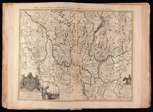
Land-Charte des Chur-Fürstenthums Brandenburg [cartographic material].
- Creator:
- Busch, Georg Paul, d. 1756, engraver
Cóvens et Mortier, printer
Gundling, Jacob Paul, Freiherr von, 1673-1731
L'Isle, Guillaume de, 1675-1726. Atlas nouveau - Published/Created:
- Amsterdam :
Bey Johannes Covens und Cornelius Mortier,
[1742] - Physical Description:
- 1 map : hand col. ; 45.5 x 58.0 cm.
- Notes:
- "G.P. Busch sculpsit".
Title in ms. on verso. Stamp on verso: 305. Sheet measures 54.2 x 67.5 cm. No. 28 of 34 maps bound together.
From Guillaume de L'Isle's Atlas nouveau.
Includes illustrated cartouches.
Prime meridian: Ferro.
Relief shown pictorially.
Shows settlements, universities, roads, forests, rivers, etc. - Variant Titles:
- Nova Electoratus Brandenburgici tabula edita per I.P. Fr. von Gundling
- Topics:
- Brandenburg (Germany)--Maps--Early works to 1800
Poland--Maps--Early works to 1800 - Language:
- German
Latin - Scale:
- Scale [ca. 1:540,000]
- Coordinates:
- 010.800000
016.283333
053.833333
051.583333
(E 10°48ʹ--E 16°17ʹ/N 53°50ʹ--N 51°35ʹ). - Genre:
- Maps--Poland--1742.--local
- Format:
- Map
- Content Type:
- Maps, Atlases & Globes
- Rights:
- The use of this image may be subject to the copyright law of the United States (Title 17, United States Code) or to site license or other rights management terms and conditions. The person using the image is liable for any infringement.
- Access Restrictions:
- Public
- Call Number:
- 1977 Folio 177
- Orbis Record:
- 9675867
- Yale Collection:
- Beinecke Library
- Digital Collection:
- General Collection, BRBL, Yale University
- oid pointer:
- 10589731
- Citation:
- Koeman, C. Atlantes Neerlandici, II, C & M 8 (map 58)
- OID:
- 10563640
- PID:
- digcoll:3795538