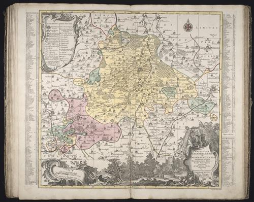
Praefecturae Altenburgensis et Ronneburgensis earumque vicinia serenissimo Duci Saxo Gothano parentes geographica tabula / [cartographic material] / expressae a Matthaeo Seuttero, Geograph. Caesar
- Creator:
- Lotter, Tobias Conrad, 1717-1777
Seutter, Matthaeus, 1678-1756 - Published/Created:
- Aug. Vindelicor. [Augsburg]
Anjezo im Verlag bey Tob. Conr. Lotter, Geogr
[ca. 1758] - Physical Description:
- 1 map
color
47.8 x 49.2 cm. - Topics:
- Atlases, German --Early works to 1800
- Topics:
- Altenburg (Germany : Landkreis) --Maps --Early works to 1800
Greiz (Germany : Landkreis) --Maps --Early works to 1800 - Language:
- Latin
- Genre:
- Atlases
Engravings
Hand coloring
Maps
Maps in books
Marginalia - Format:
- Map
- Rights:
- The use of this image may be subject to the copyright law of the United States (Title 17, United States Code) or to site license or other rights management terms and conditions. The person using the image is liable for any infringement.
- Access Restrictions:
- Public
- Source Creator:
- Homann Erben (Firm)
- Source Title:
- [Atlas factice of 32 maps and 1 distance table, produced by the Homann Erben firm]
- Source Created:
- [Nuremberg : s.n., 1701-1760]
- Call Number:
- 1973 Folio 30
- Orbis Record:
- 9116788
- Yale Collection:
- Beinecke Library
- Digital Collection:
- General Collection, BRBL, Yale University
- oid pointer:
- 1278106
- Extent of digitization:
- Complete work digitized.
- OID:
- 2065703
- PID:
- digcoll:3595048