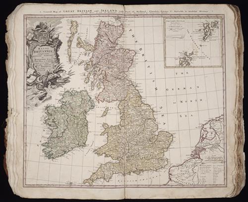
Magna Britannia complectens Angliae, Scotiae, et Hyberniae regn [cartographic material] : in suas prov. et comitat. divisa et ex mappis Londinensibus designata / per Homannum
- Creator:
- Homann Erben (Firm)
Homann, Johann Baptist, 1663-1724 - Published/Created:
- Nuremberg
Homann Erben
1729 - Physical Description:
- 1 map
color
46 x 54.2 cm. - Variant Titles:
- General map of Great Britain and Ireland with part of Holland, Flanders France &c. agreable to modern history by the heirs of late Mr. Homann at Nuremburg, priviledged by Emperours Majesty
- Topics:
- Atlases, German --Early works to 1800
- Topics:
- Great Britain --Maps --Early works to 1800
Ireland --Maps --Early works to 1800 - Language:
- English
Latin - Genre:
- Atlases
Engravings
Hand coloring
Maps
Maps in books - Format:
- Map
- Rights:
- The use of this image may be subject to the copyright law of the United States (Title 17, United States Code) or to site license or other rights management terms and conditions. The person using the image is liable for any infringement.
- Access Restrictions:
- Public
- Source Creator:
- Hase, Johann Matthias, 1684-1742
Homann Erben (Firm)
Homann, Johann Baptist, 1663-1724
Mayer, Tobias, 1723-1762
Ovalle, Alonso de, 1601-1651 - Source Title:
- [Atlas factice of 42 maps, produced by the Homann Erben firm]
- Source Created:
- [Nuremberg,
1710-1748] - Call Number:
- 1975 Folio 31
- Orbis Record:
- 9108723
- Yale Collection:
- Beinecke Library
- Digital Collection:
- General Collection, BRBL, Yale University
- oid pointer:
- 1276000
- Extent of digitization:
- Complete work digitized.
- OID:
- 2065623
- PID:
- digcoll:3594543